Previous Chapter 1 - Irish History Next Chapter 3 - Standing Armies and Militias
Chapter
2 - Coleraine History
Naming
Coleraine
Coleraine
(Cuil Rathain) has been interpreted as either “the ferny
corner” or “the rath at the bend of the waters”. Either
interpretation suits the topography of Coleraine at the time.
Mullin (1998) has suggested that the rath referred to was probably
the earthen structure on which the Citadel was later built. This
feature was located where Hanover Place now stands.
Coleraine
Name Changes
County
Londonderry was originally known as O’Cahan’s land. In 1584 Sir
John Perrott the Lord Deputy relocated Coleraine town at
Drumtarsey, now called Killowen and then in 1585 all of
O’Cahan’s land, parts of Tyrone and Donegal became County
Coleraine.
The sloping ground of Drumtarsey and the sand bar at the
mouth of the River Bann made Coleraine unsuitable for a major town
location. Derry city had a better harbour facility and was then
selected as the major town. The county name was changed to
Londonderry in 1610. Coleraine town was then relocated in its
former position in County Antrim.
In 1610 the Londoners came to an agreement with Sir Randal
MacDonnell, the lord of County Antrim. Coleraine town, the
fisheries and an area with a three-mile radius around Coleraine on
the east side of the Bann became part of Co Londonderry. That
three-mile area was taken over and developed by The Honourable The
Irish Society itself. This new territory was known as The
Liberties.
Coleraine
Town Plan
The
plans for the layout of Coleraine town were drawn up by Sir John
Perrott and were similar to the plans for Londonderry city. The
Irish Society started building and developing Coleraine in 1610 and
good progress was reported up to the year 1611. By 1612 the
building programme was bedevilled with corruption and incompetence
as those tasked with developing the town spent most of their time
on stripping the countryside of the rich natural resources for
their own gain.
The fortifications of the town were five earthen ramparts
with the sixth side faced the River Bann. The ramparts were six
feet high and sixteen feet thick with twelve feet bulwarks inserted
at irregular intervals. The bulwarks were too narrow to be used as
artillery locations.
A
four-foot wide and four-foot deep trench was dug outside the
ramparts and in some places this was serviced by spring water to
create an obstacle. The total distance around the town defences was
2,000 yards. This measurement shows that Coleraine town and
defences were half the size of Derry.
A drawbridge and gate was placed at each of the two
entrances into the town. The King’s Gate was located at the end
of the main road where St Patrick’s church ground ends. The Blind
Gate was located centrally in the fourth rampart facing due south. The only remaining vestige of these 400-year-old
fortifications is the north rampart that drops down into Anderson
Park behind St Patrick’s church.
Construction of the town Citadel started in 1650. It was
supposed to look like a miniature castle with high walls and
ramparts. One of the few ever built in Ireland still exists in
Limerick. By 1662 the Coleraine Citadel was only 10 to 12 foot
high, the walls were unfinished and no ramparts had been added
(Kerrigan, p101). In 1670 it was referred to as ‘the late
demolished citadel’ (Mullin, p105).
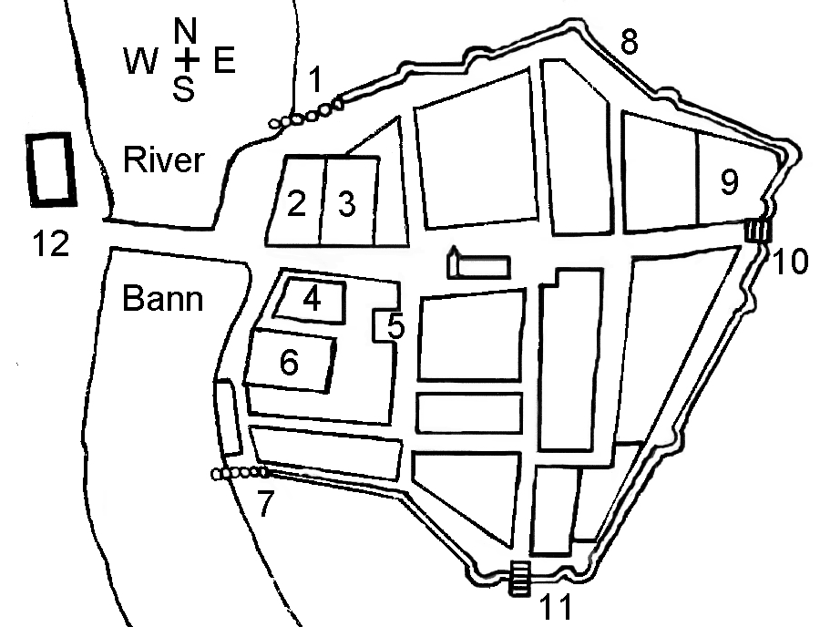
The
following map is a composite map showing the general layout of
Coleraine town as it evolved between 1609 and 1850.
Legend
North
Palisade
Customs
House
The
Barracks
The
Abbey (Dominican monastery)
The
Shambles (Meat Market)
The
Citadel
South
Palisade
North
Ramparts
St
Patrick’s Church
King’s
Gate and Drawbridge
Blind
Gate and Drawbridge
Drumtarsey
Castle
The
town remained fortified for 100 years until the early 1700s when
the town started to expand beyond the boundaries of the ramparts.
The town defences were never improved upon other than being
repaired and strengthened for the 1798 Rebellion.
The
Town Watch
The
townspeople were responsible for manning the town watch. The
records show that the watch was operating from October 1678 until
April 1706.
Mullin
(1979, p49) explains that in 1862 a superintendent and six watchmen
operating from 9pm until 4am in the summer and 6am in the winter.
Their main role was policing the town and fire watching. They were
stood down when the constabulary were established in Newmarket
Street in 1862.
The
Plantation of County Londonderry and Coleraine Town
County
Londonderry had to be settled differently from the other counties.
Planters and undertakers had been ignoring the county despite it
having the best land in Ulster. Their main concern was that Sir
Donnell, the O’Cahan chief, would be released from the Tower of
London and return with his ferocious clansmen to reclaim his lands
(Falls, p176). In the end the king demanded that the London
Companies should settle the county.
The
Londoners’ Plantation
When
the Plantation started many of the surviving native Irish lost
their land and were ordered,
“…to
depart with their goods and chattels at or before the first of May
next (1609) into what other part of the realm they pleased.”
(Joyce para 525).
County
Londonderry was then settled in what was known as The Londoners’
Plantation. The first grants were made to The Irish Society who was
directly responsible for developing both London-Derry and Coleraine
towns and the attached Liberties around both towns. The second
grant was made to the twelve London Livery companies who acted as
landlords.
The third grant of twenty-five percent of the land went to
the native Irish freeholders. Those who lost property in the
redistribution such as Sir Thomas Phillips and finally, the
Protestant Bishops were also granted land. Any map outlining this
allocation of land in Co. Londonderry is represented by a patchwork
of approximately 150 plots of land covering the whole county.
One
of the best-known Livery Companies was the Clothworkers. They were
granted the land on the west of the Bann where they were
responsible for building the Clothworker’s building at the end of
the Bann Bridge and developing the Killowen area.
The
Obligations of the Livery Companies
When
the Livery Companies were allocated their portions of land they had
to undertake certain obligations within the first three years to
settle people on their plots of land for its cultivation. The
Londoners failed to attract enough settlers to Ulster because the
confiscated territory was ten times larger than the initial
estimate. For that reason and counter to their obligations, many
settlers retained the native Irish on their lands to ensure it was
cultivated.
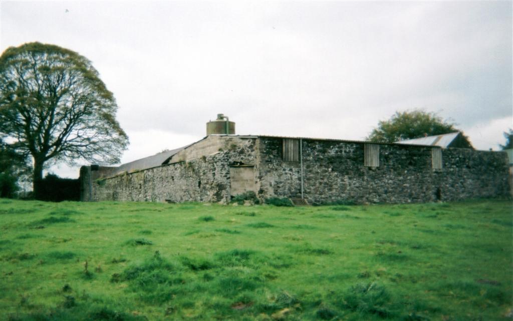
Those
allocated 2000 acres had to build a stone castle and surround it
with a stone enclosure (Bawn). One of these is still standing at
Movanagher near Kilrea. Those allocated 1500 acres had to build a
stone house and surround their immediate dwelling with a bawn.
Those allocated 1000 acres also had to surround their immediate
dwelling with a bawn.
Photo3.
Movanagher Bawn
Each
of the undertakers then had to bring in at least twenty-four
Scottish or English Protestant tenants to live on each 1,000 acres
allocated to them. They all had to be over the age of 18 years.
These tenants were expected to build their family homes close
together near the undertaker’s home so that there was a high
degree of mutual protection. In some cases there was no requirement
for the settlers to build their own homes.
“Irish
houses from which the owners were to be turned adrift should be
preserved for the use of the English settlers throughout……..”
(Hill, p367)
The
undertakers were further obliged to store and issue the arms
necessary for the defence of their plots and parade their tenants
every six months. This form of military service was similar to the
militias used in England.
Churches
and Abbeys
Many
churches, monasteries and abbeys in the Coleraine area have been
established and in turn plundered and destroyed during the town’s
turbulent history. The dominant religion of the Coleraine area in
its early history was the Celtic Christianity of St Patrick.
Starting in AD 1172, this faith was steadily replaced by Roman
Catholicism. When the Protestant Plantation started in 1610 the
parish churches of St Patrick’s and St John the Baptist
(Killowen) became Protestant churches.
St
Patrick’s Church

Legend
has it that Coleraine was given its name by St Patrick. This
happened in AD 432 when a local chieftain called Nadslua gave St
Patrick some ground on the east bank of the Bann to build his
monastery (O’Laverty, p161).
The grandson of Nadslua was to become the Bishop of
Coleraine.
The
monastery survived until 1213 when it was demolished along with all
other stone edifices in the town but the church survived. Thomas de
Galloway conducted this act of vandalism. It provided him with most
of the material he needed to build a castle on the west bank of the
Bann. There he destroyed the abbey founded by St Carbreus in 540
and built Coleraine castle on the foundations. The site was located
just behind the grounds of the County Hall. Coleraine Castle was
destroyed in 1221 and rebuilt in 1228. The church of St Patrick has
thrived well in the middle of the town ever since.
St
Mary’s Dominican Abbey
In
the mid 1200s the MacEvelins founded the Dominican monastery of St
Mary’s in Coleraine on the east bank of the Bann (Carlisle,
1810). It was located in the southern limits of the present Diamond
building. In 1556 the Dominicans abandoned St Mary’s and it was
granted to Sir James Hamilton. He transferred the ownership to Sir
Thomas Phillips in 1604.
When Sir Thomas Phillips was developing Coleraine town as a
private enterprise between 1605 and 1610, he fortified the abbey
and used it for his private accommodation (Mullin1976, p29).
Despite this interruption, St. Mary’s became the first university
in Coleraine when the Dominican Order assigned it that status in
the year 1644. The Dominican order may have been relocated in the
Coleraine area because the last known Dominican from St Mary’s
was called Father JD Cunningham who died in1843 (Coleman 1902, in
Mullan & Donnelly, 1992, p93).
Killowen
Church and Maconachie Hall
The
name Killowen dates back to 1607 and it is derived from a
misinterpretation of the Irish ‘Kill Eoghain’ or the Church of
St Eugene. Before that date the area was known as Drumtarsey,
‘the ridge on the other side’.
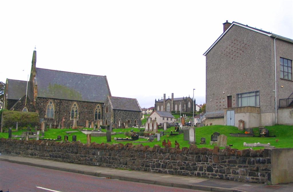
The
Roman Catholic Church of St Eugene, later called St John the
Baptist (1609) was situated within the northern boundary of the
present Killowen graveyard. It was built in 1248 by the
Anglo-Normans to be used by the soldiers garrisoned at Drumtarsey
Castle as well as the settlers of Drumtarsey (Machonachie, p6).
Photo
4 Killowen Church, St Johns and Maconachie Hall
At
the start of the Plantation the Protestant settlers confiscated the
church. It was restored in 1616 and renovated in 1690 and 1767.
Also at the start of the Plantation, the Roman Catholic faith was
outlawed to the extent that the Protestant Bishops inherited their
land and no Roman Catholics or mere (pure) Irish were permitted to
reside in Coleraine town. That restriction zone extended from the
Irish Houses on the northwest side of the town at the top of the
Cart Haul (Carthall) road, Laurel Hill on the south and Spittal
Hill on the east (MacLaughlin, p8). Every day before sunset, all
Roman Catholics and the mere Irish still inside the restricted zone
were warned to leave the town by the ringing of the Curfew Bell.
Location of the Curfew Bell
The
James O’Hagan map (1845) refers to the location as the Old Church
and then the Valuation Map (1858) refers to the location as the
Parochial House.
The present Protestant church at Killowen was then built in
1830. After that date the origional Roman Catholic church was used
as a parochial school until the new school was built in Shuttle
Hill. The old Roman Catholic church then became known as the
Parochial Hall.
Martha
Gamble was born in 1922 and recalls, ‘My mother died when I was
three years old and I had to go and live with my grandmother on
Kyle’s Brae in the house beside the upper chapel gate. The
Reverend Abbot would visit my grandmother once every three months
and give her £3 from the Protestant Orphan’s Fund. She would
fold up a towel for him to kneel on when we prayed together. In
1927 I started school at the Killowen Public Elementary school. We
had to bring our own aluminium cups to school with us and for the
break we would go to the Parochial Hall for a cup of cocoa. Mrs
McKay from Strand Terrace was there to ladle the cocoa out from a
big boiler and I remember there was a photo of the Reverend Giles
hanging on the wall’.
In
1938 the Ministry of Education School was built directly across the
road. The Elementary School is now Killowen Orange Hall. The
Parochial Hall remained in use until it was demolished in 1961 and
Maconachie Hall was built on the foundations.
The
Mass Walk and St Johns
The
Roman Catholic parishioners displaced from St Eugene’s during the
Protestant plantation started to attend open air mass on ‘The
Mass Walk’ in the Somerset demesne lands (pronounced demean,
meaning owned by a lord) (Mullan & Donnelly, p140). This was
located on the Garrett Screen Road opposite the present Greenmount
Estate.
In the mid-18th Century the Roman Catholic
population of Coleraine town started to increase. Many native Irish
came to the town from the Limavady hills and Co Donegal; the places
their ancestors had been banished to in the early years of the
plantation (Mullan & Donnelly, p 155).
In 1760 the Wayside Chapel was built close to the Mass Walk
at Burnside. It had a thatched roof and was 50 feet long and 14
feet wide. At that time many Roman Catholics continued to exercise
their right to be buried in the Protestant Graveyard (MacLaughlin,
p6) where their Roman Catholic ancestors were buried.
The Wayside Chapel was vacated when the new Roman Catholic
Church was built in 1806. This building was unsafe and had to be
demolished. The present Roman Catholic Church of St John the
Evangelist, Killowen, replaced it. By the year 1835 it was almost
complete but another 20 years would pass before a wooden floor
replaced the earthen floor.
The Wayside Chapel was then converted into four labourers’
cottages. One of the last occupants was a character called
Constable Hemmingway. All that remains of the Wayside Chapel today
is the base of the north wall close to the modern cottage that was
built inside the old foundations.
Photo
5. Former Location of the Wayside Chapel

Castles
Coleraine
Castle
In
1213 Thomas de Galloway dismantled the Abbey of St Carbreus and
erected Coleraine Castle on the same ground (Lewis, p18). The
castle was destroyed in 1221 by Hugh de Lacy and Hugh O’Neill and
was then rebuilt in 1228 (Mullin p13).
When King James I granted a lease for the property to the
Clothworker’s Company in 1609 there was a cottage located on the
castle foundations. Later on William Jackson demolished the cottage
and built Jackson Hall. It finally became known as the Manor House
and was demolished to form part of the car park at the rear of the
County Hall.
Drumtarsey
Castle
There
was only one castle located in Coleraine town at the time of the
Plantation, Drumtarsey Castle. This castle and the first Bann
Bridge were built in 1248 by the Anglo-Normans. Both were located
close to the present Clothworker’s Bridge. O’Neill rebuilt
Drumtarsey castle in 1564 and it was still there in a ruined state
in 1608 (Mullin, p27). In 1619 Sir Robert McClelland built a castle
of lime and stone behind the present location of the
Clothworker’s building. It was 54 feet long, 34 feet wide and 28
feet high.
Bridge Street, Bridge and Captain Street in the distance. Drumtarsey Castle was located behind the large building at the far side of the bridge on the right.

Artefacts
Two
artefacts presented to Coleraine Corporation by the Honourable The
Irish Society have survived Coleraines tumultuous past, the Sword
and the Mace.
The
Sword
Andrea
Ferrara was a legendary sword smith from Spain. He was forced to
flee to Scotland during the reign of James V after murdering one of
his apprentices for spying on his manufacturing processes.
He established himself in Scotland as a sword smith and his
Basket Hilt Broadsword as well as his Claymore (great sword) became
known as a ‘Ferrara’.
On 27 July 1616 Alderman Probyn and Mathias Springham were
visiting the town on The Irish Society’s business when they
presented the Corporation of Coleraine with a Ferrara. This was a
gilded double-edged weapon with an overall length of 48 inches. The
makers name and mark are engraved on the blade. The scabbard is
still intact and is covered with crimson velvet. It has survived
intact to the present day even though it has been reputed to have
the flexibility of all Ferrara swords in that the blade can be bent
until the tip touches the hilt.
The
Mace
Eighty-six
years later, during the reign of Queen Anne in 1702, the Irish
Society presented the Corporation of Coleraine with a ceremonial
mace. The head bears the Royal Arms and the side has a harp
surmounted by the crown, shamrock, thistle and rose and the
initials AR (Anne Regina).
There
are also two inscriptions on the mace. The first one states,
“This
mace was given to the Corporation of Coleraine in the year 1702 by
the honourable the trustees appointed by Act of Parliament made in
Scotland for ye sale of ye forfeited and other estates and
interests in Ireland”.
The
second inscription is more recent and states,
“To
commemorate the signing of the Peace, 28 June 1919 after the Great
War, 1914–1918, this mace was gilded at the cost of the Hon. The
Irish Society, Sir Alfred J Newton, Bart, Governor”.
Previous Chapter 1 - Irish History Next Chapter 3 - Standing Armies and Militias